Westhaven Gold Corp.
1056 - 409 Granville Street
Vancouver, B.C. Canada V6C 1T2
info@westhavengold.com
Details
NI43-101 Technical Report on SBGB Group of WHN Gold Properties (20 MB)
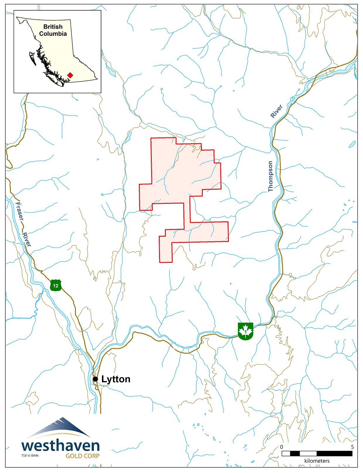
Skoonka
The Skoonka property is situated near the northern end of the Spences Bridge Gold Belt (SBGB), a series of Cretaceous subaerial volcanic rocks with the potential to host epithermal-style mineralization. The property is a three hour drive by car from Vancouver, situated between the communities of Lytton and Spences Bridge in south-central British Columbia approximately 10 kilometres north of the Trans-Canada Highway and the CPR Railway Line. Westhaven owns 100% interest in the 2,785 ha property, comprising 10 contiguous claims.
A number of epithermal gold prospects and showings have been discovered on the property including the JJ, Discovery, Deadwood, Ember, Backburn and Zebra prospects. The Discovery, Deadwood, Ember, and Backburn showings define the Deadwood-Backburn trend (the "DBT"), a 3,000 m long east-west trending structural corridor defined by weakly to strongly clay and silica altered volcanic rocks and coincident gold in soil geochemical anomalies.
Styles of mineralization identified within the property include (1) multi-stage massive veins with associated breccia zones and intense proximal silica to distal argillic alteration (e.g. JJ, Ember, and Discovery) and (2) narrow stockwork veinlets with moderate, albeit pervasive silica and minor clay alteration (e.g. Deadwood and Backburn). Mineralization is associated with early east-west, moderately to steeply-dipping normal faults. In general, the gold showings appear to occur between 100 and 300 m below a formational contact within the Spences Bridge Group, which has been postulated to be a paleosurface during hydrothermal activity and epithermal mineralization.
Access to the Skoonka Property was complicated by a series of unfortunate events beyond Westhaven’s control, including the Covid 19 pandemic (2020), fires that devastated the community of Lytton (2021) and floods that washed out roads and bridges.
During 2022 Westhaven was able to complete a 16 hole drill program (3,337m) at the JJ and JJ West targets, as well as an airborne LiDAR survey. The LiDAR data was used for structural, lithological and steam channel mapping, whereas the drilling provided important information about the existing JJ mineralization and identified a potential extension 900m southwest at the previously undrilled JJ West target.
An archeological survey over additional potential drill targets was completed in 2023, but forest fires in each of 2023 and 2024 prevented ready access to the claims. Subsequent evaluation of historical data has identified new targets for mapping, prospecting, sampling and geophysical surveys. Westhaven plans to continue exploration on the property to develop and prioritize potential drill targets as soon as logistical conditions return to normal. Some of the more interesting mineralized showings are summarized below.
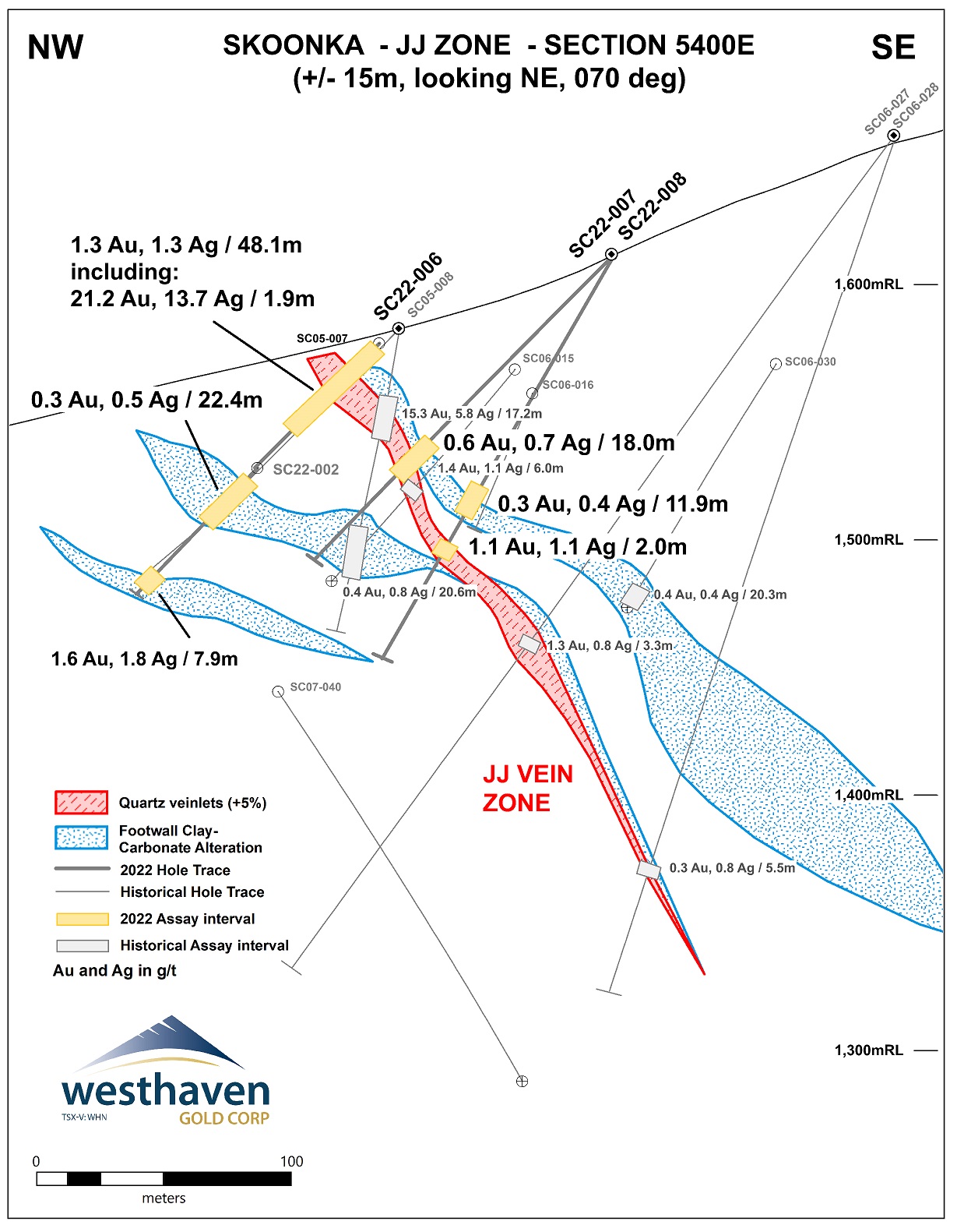
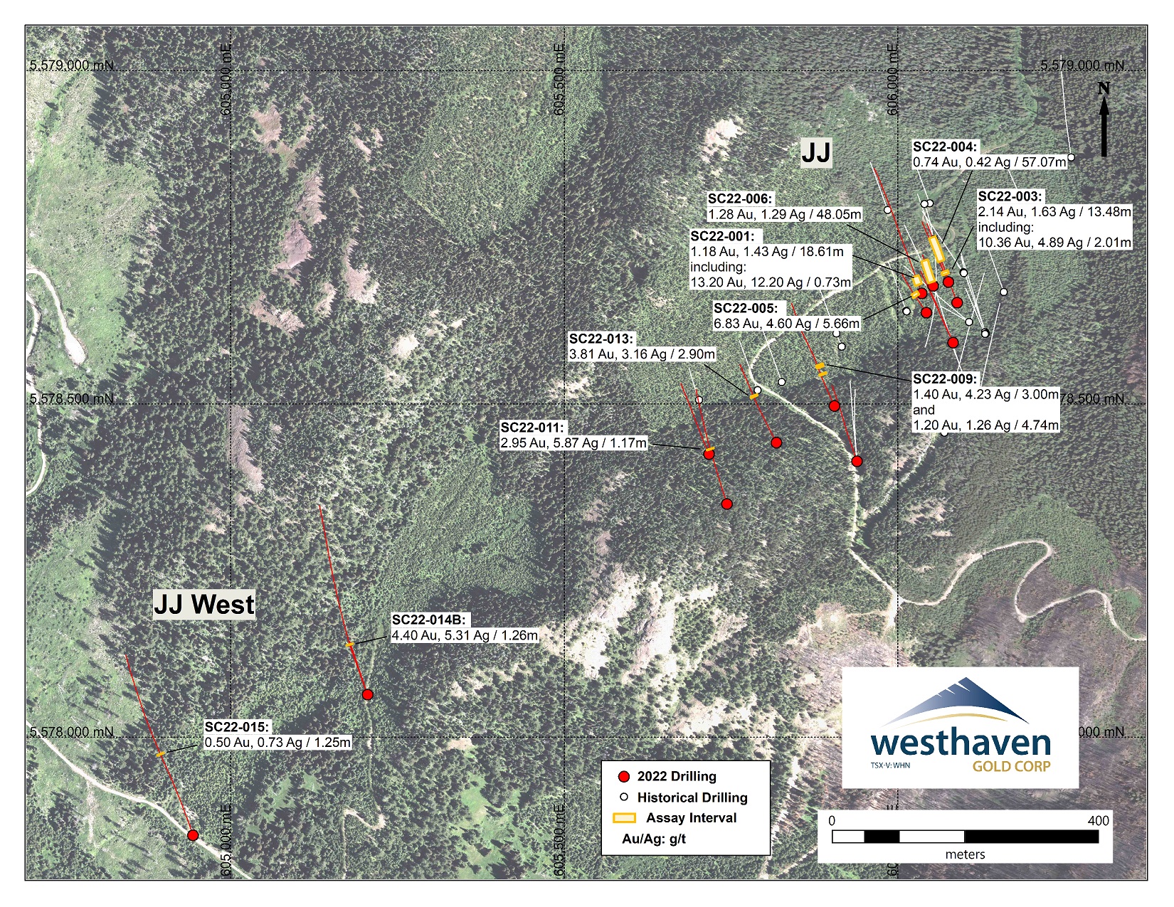
JJ Zone
- JJ vein system comprises two main quartz veins (traced on surface for 175m by a series of trenches) and situated within an alteration envelope from 4 to 20m thick.
- represents high-grade epithermal, bonanza style, gold mineralization associated with quartz veining and quartz breccias
- best gold grades are in well developed epithermal quartz veins
- lower grades (<1 g/t) are located within a more extensive zone of footwall mineralization associated with brecciation, alteration and quartz-carbonate veining occurring in various host rocks (predominantly andesites and basalts)
- example intersections of both include;
- 20.2 g/t gold over 12.8 m (historic drill hole SC05-008)
- 1.28 g/t gold over 48.05m including 21.15 g/t gold over 1.90m (2022 drill hole SC22-006)
- 6.83 g/t gold over 5.66m including 12.35 g/t gold over 2.77m (2022 drill hole SC22-005)
- 0.52 g/t gold over 21.04m (2022 drill hole SC22-003)
- 2022 drilling intersected the JJ vein zone over a strike length of 440m with a series of twelve holes spaced 25 to 185m apart
- combined with historic drilling, the JJ vein zone now extends over a strike length of 590m with a down dip extent of up to 240m from surface and may extend 900m southwest to JJ West (see below)
- mineralogical, textural and geochemical evidence indicates that mineralization encountered to date represents the upper portions of a shallowly eroded low sulphidation epithermal system, with good potential to discover more consistent and higher gold grades at greater depths;
- mineralization remains open along strike and to depth.
JJ West Zone
- soil sampling, rock sampling and prospecting undertaken some 900m southwest of the JJ Zone identified anomalous pathfinder elements and quartz veining in float and outcrop in an area referred to as JJ West
- high-level pathfinders at JJ West are coincident with an airborne magnetic low of similar amplitude and directly on strike from the JJ vein zone
- three drill holes collared in 2022 at JJ West successfully intersected the JJ vein zone some 600m southwest of the nearest JJ holes, and then again an additional 300m to the southwest (SC22-014B and SC22-015 respectively)
- thick sections of andesite and andesite breccia in the vein footwall, are variably bleached, locally very pyritic, and cut by trace to 1% millimetre scale, sometimes banded, quartz-pyrite veins
- these sections host a number of lower grade intervals where gold and arsenic grades tend to be associated with stronger bleaching
- grades to date are generally low (e.g. 0.50 g/t Au over 1.25m in SC22-015 and 0.19 g/t Au over 98.64m in SC-014B) but the presence of pale grey to white massive to banded chalcedony veins with hairline bands of black ginguro and elevated molybdenum/arsenic confirms the exploration potential
- future drilling will target an undercut to see if the vein zone focusses down to a more constricted but stronger zone with better grades as is often typical of high-grade gold epithermal systems
- gold endowment at JJ West, 600m southwest of the drilled portion of the JJ vein zone, suggests the potential for continuation of mineralization over this untested strike length
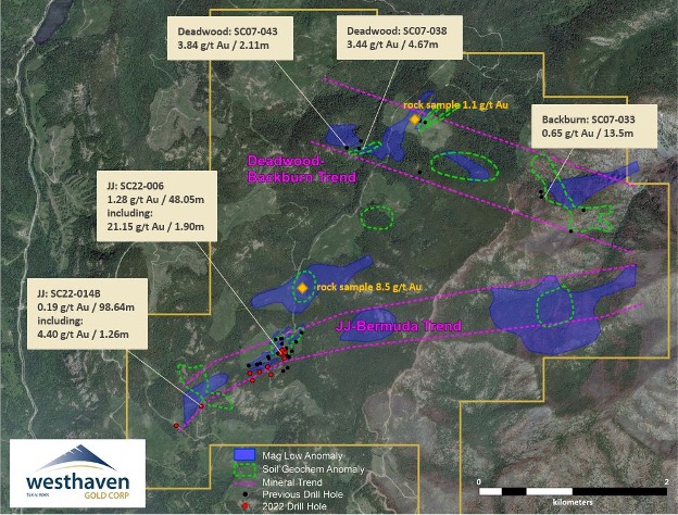
Discovery Showing
- surface sampling of a low grade quartz breccia vein along the northern edge of the DBT returned 0.38 g/t gold over a width of 4.2 m;
- tested by 3 drill holes returning results of 11.33 m grading 0.36 g/t gold, 3.49 m grading 0.14 g/t gold, and 5.53 m grading 0.21 g/t gold;
- mineralization is associated with alteration and quartz breccia zones and occurs within epithermal vein textures typical of low sulphidation epithermal systems.
Deadwood Showing
- located at the western end of the DBT, 800 m to the west-southwest of Discovery;
- gold mineralization has been identified within silicified volcanic rocks over a 250 m strike length and remains open;
- 193 bedrock grab and chip samples have returned from background values up to 14 g/t Au with 39 samples returning in excess of 1 g/t Au;
- bedrock chip sampling near some of the better grab samples has returned 2.6 g/t Au over 13.0 m, 1.1 g/t Au over 7.0 m and 0.65 g/t Au over 7.0 m;
- drill tested by 6 historic holes;
- 3.39 g/t gold over 4.67m (SC07-038);
- 6.43 g/t gold over 1.2 m (SC07-039);
- 0.67 g/t gold over 14.9 m (SC07-040);
- better mineralization is typically located at shallow depths;
- tracing and defining the mineralized intervals at Deadwood is complicated by a series of post mineralization feldspar porphyry dykes and faults.
Ember and Backburn Showings
- the Ember and Backburn targets are located between 500 m and 1,200 m east of Deadwood in the central and eastern DBT, respectively;
- Ember has an east-west strike of 240 m and a width of 65 m;
- historic drilling at Ember (2 holes) encountered massive to locally brecciated and stockwork veins down to a depth of 45 m;
- 0.18 g/t gold over 9.80 m (SC07-035);
- Backburn consists of a prominent soil anomaly (313.24 ppb Au over 20 m) and two occurrences of quartz stockwork veins and silica-carbonate alteration (1.52 g/t Au over 10 m)
- historic drilling at Backburn (4 holes) encountered narrow zones representing weakly to moderately silica, carbonate, and/or chlorite alteration
- 0.78 g/t gold over 10 m (SC07-033).
Additional targets of potential interest on the Skoonka Creek property include well defined soil anomalies, undrilled gold/silver mineralization in outcrop, linear airborne and ground geophysical features striking parallel to the JJ vein system zone, and the potential projection of JJ eastward about 2.5km under a thin veneer of cover rocks to the as yet undrilled Bermuda zone.