Details
Skoonka North
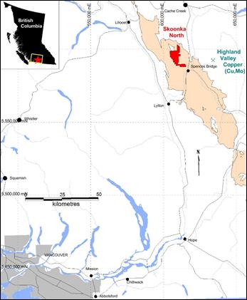
The Property consists of 3 contiguous mineral claims encompassing 6,167 hectares wholly owned by Westhaven Gold Corp. The Property is situated 1 kilometre northwest of the community of Spences Bridge in south-central British Columbia, within the Kamloops Mining Division.
The Property is located within the southern Intermontane Belt of British Columbia, which is dominated by the Upper Triassic Nicola Group, a west-facing magmatic arc sequence comprising the south end of the Quesnel Terrane. These rocks are intruded by Late Triassic and Early Jurassic comagmatic plutons, and are unconformably overlain by Cretaceous and Tertiary volcanic rocks and clastic sediments of Spences Bridge Volcanic Belt and Princeton Group. At property scale, the Skoonka North Property is underlain entirely by the Spences Bridge Group basal Pimainus Formation consisting of conglomerates, pyroclastic-dominated volcanic rocks, and andesite flows (previously mapped as fine-grained crystal tuffs).
The Skoonka North claims have the highest gold silt samples on the Spences Bridge Gold Belt (SBGB), including 594 parts per billion (ppb) Au, 383.7 ppb Au, and 131.3 ppb Au. The claims have seen limited exploration work and have yet to be drill tested.
The first target is a prominent, linear topographic feature that extends from the northeast corner of the property to the center of the claim group, extending north-northeast for 6 km. The southernmost 2.5 km occurs along the east flank of a north-northeast trending magnetic low. The target is marked by anomalous stream silts of 383.7 and 131.3 ppb Au at its south end and 53.7 ppb Au at its north end. This corridor has seen limited prospecting to the east of its central portion and immediately west of its southern third, where a soil grid was laid out.
The main anomaly that has received the most work, including trenching, has returned rock and soil assays of up to 2.0 g/t Au and 701 ppb Au, respectively. The anomaly has been traced northeast for 260 m. Trenching has exposed a 55 m-long, east-trending zone of carbonate-zeolite veining assaying up to 1.44 g/t Au. A third target comprises a northeast trending corridor containing geochemistry anomalies (soils up to 41.9 ppb Au) and an anomalous silt sample assaying 89.6 ppb Au. This occurs along the west flank of a north-northeast trending magnetic low and on the west flank of a north trending potassium radiometric high anomaly.
Rock samples taken from the showing contain anomalous gold with fine disseminated pyrite associated with millimetre-scale east-west trending zeolite and/or ankerite veining. Veining is hosted in an amygdaloidal, porphyritic andesite flow. Alteration minerals associated with this zone include pervasive chlorite, and hematite and kaolinite on fractures. Other minor alteration styles include argillic (visible on fracture surfaces) and silica (in the matrix). This showing corresponds to a northeast-trending lineament reflected topographically (Gale et al, 2006). Other minor mineral occurrences observed on the Property are limited to pyrite occurrences scattered throughout the area.
The 2018 exploration program consisted of flying helicopter-borne magnetics and radiometrics surveys over the entire Property. The magnetics survey delineated strong northeast trending magnetic high and low linear anomalies.
The Property is accessible by ground transport within a 3.5 hour drive from Vancouver, BC. Access to the Property from Spences Bridge, the nearest community, is via the Murray Creek forestry service road (FSR), accessed from Highway 1 on the western side of the Thompson River. Alternatively, the Property can be accessed via the Laluwissin FSR off Highway 12 north of Lytton.
2018 Airborne Geophysics Program
Precision GeoSurveys of Vancouver, BC was contracted to complete an airborne magnetics and radiometrics survey across the entire property. The survey was completed November 14 and November 18 to 20, 2018. East-west oriented lines were flown at 100 metre line spacing with 1000 metre north-south oriented tie line spacing (695 line-km). An Airbus AS350 helicopter was used for the survey flying at a mean flight height of 45.3 metres above ground surface. Data locations were recorded with a WAAS-enabled GPS navigation system integrated with pilot steering display and data logger with an estimated flight line accuracy of +/- 10 metres from desired track.
INTERPRETATION AND CONCLUSIONS
The magnetics survey delineated strong generally north to northwest trending magnetic high and low linear anomalies often extending to 2 km long.
K% radiometrics show well defined anomalies to the southeast portion of the Property, in the area noted for the presence of felsic intrusives.
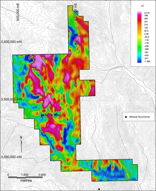
Total Field Magnetics (Reduced to Pole)